|
|
 |
 |
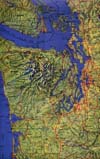
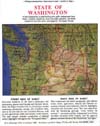
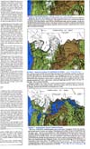
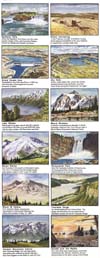
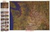
STATE OF WASHINGTON and Adjacent Parts of Oregon, Idaho, and British Columbia: Published in 1976, but revised in 1996 to include numerous additional features. The 24" x 37.5" map sheet now includes the "new" Mount St. Helens (since the 1980 eruption), a dozen watercolor views of selected scenic features throughout the state. Now printed on the backside, the map is designed as an educational tool, with a text that sumrnarizes the state's geographic setting (climate and weather), its natural resources (water, timber, fisheries, minerals), economy and culture, historic highlights, and recreational resources (state and national parks and wilderness and recreation areas. Text and maps describe the geologic "story behind the scenery" from early Tertiary time through the Pleistocene "Ice Ages" Epoch—with its volcanic activity, vast glacier advances into and retreats from the area, and the gigantic floods that periodically inundated eastern Washington, to form the coulees of the Channeled Scabland. This map is popular as a wall display in geography and earth-sciences classrooms, and in offices of State officials and members of Congress. The late Senator Warren Magnuson had written, "I have not seen a map of Washington previously that includes such exquisite detail." JamesChamberlain, formerly top official of the U.S. Geological Survey's Topographic Division, wrote, "You are to be congratulated for anoutstanding contribution to cartography." |
|
 |
|