 |
 |
 |
||||||||||
|
Mount Rainier Washington USA
|
||||||||||||
 |
 |
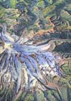
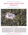
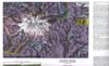
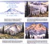
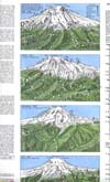
MOUNT RAINIER NATIONAL PARK, WASHINGTON: Published in 1965 and periodically updated, this 24" x 37.5" map sheet is a product of Dee Molenaar's many years of close association with "The Mountain", as summit guide, park ranger, geologist, and historian. The map is widely acclaimed as the most accurate artistic portrayal of the mountain and surrounding foothills. Along the map's margin are watercolor landscapes that depict the peak as seen from key viewpoints. The backside of the map sheet includes a geologic map, sketches, and text that describe the mountain's geologic setting and glaciers, snowfall and weather, mountaineering history, hiking and climbing regulations, and a summary of what can be seen from over 70 key viewpoints along Park roads and trails. Molenaar's long interest in and many varied experiences on the mountain are also reflected in his awarding-winning The Challenge of Rainier: A Record of the Explorations and Ascents, Triumphs and Tragedies on the Northwest's Greatest Mountain (The Mountaineers Books,1971). |
||||||||||
 |
||||||||||||
 |
||||||||||||
 |
||||||||||||
 |
||||||||||||
 |
||||||||||||