 |
 |
 |
||||||||
|
Point Reyes California USA
|
||||||||||
 |
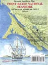 |
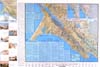
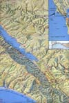
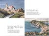
POINT REYES NATIONAL SEASHORE and the San Andreas Fault, California: Published in 1982 and revised in 1998, the 24" x 36" sheet illustrates one of the most picturesque and historically fascinating areas of coastal California. Referred to by geologists as "an island in time", the Point Reyes Peninsula is separated from the mainland by the world-famous San Andreas fault and rift zone, which extends more than 600 miles through California and northern Mexico. Two small inset maps and text present the geologic story of the San Andreas and related fault systems throughout California and Nevada. The map includes a text that summarizes the area's geology and human and natural history, along with a guide to the many scenic trails of the Seashore. Several small watercolors of the area's scenic highlights enhance the map's margin. The Seashore offers attractions to hikers and backpackers, beachcombers and surf fishermen, birdwatchers and flower lovers, geologists, artists, and photographers. | ||||||||
 |
||||||||||
 |
||||||||||