 |
 |
|||||||||||||
|
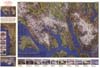
Glacier Bay Alaska USA
|
||||||||||||||
 |
 |
|||||||||||||
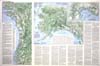
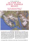
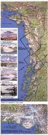
| GLACIER BAY-JUNEAU ICEFIELD REGION and the Glacierized Ranges of Alaska-Northwestern Canada: Published in 1990 and revised in 1993, this 24N x 36" map sheet is loaded with information and attractive illustrations. A product of Dee Molenaar's several visits to Alaska (including mountaineering expeditions and geological explorations), the sheet contains several maps besides the large, maintitled map; these include: (1) mainland Alaska, (2) glacierized ranges of Alaska-nonhwestern Canada, (3) BeringMalaspina Glaciers area, and (4) Chugach Mountains-Price William Sound area (Cook Inlet to Copper River). A text sGarizes the geologic and glaciological setting of Alaska, the discoveries and early explorations and mapping of the area's glaciers and the ongoing comprehensive glaciological research being carried out. Summarized is the activity at today's glaciers: advances and rapid "surges" (ice flow as much as 230 feet a day!), glacier retreats and "calving" of icebergs into lakes and marine waters, and glacier-dammed lakes with their sudden, sometimes catastrophic outburst floods. The map margin includes 21 small watercolors of selected views of mountairs and glaciers of Alaska. | 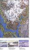 |
|||||||||||||
 |
||||||||||||||
 |
||||||||||||||
 |
||||||||||||||